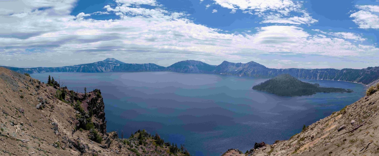
The viewpoint at Crater Lake, specifically the Sinnott Memorial Overlook, stands at an impressive elevation of approximately 7,100 feet (2,164 meters) above sea level. This vantage point offers visitors breathtaking views of the deep blue waters of Crater Lake, nestled within the caldera of Mount Mazama. The elevation of the viewpoint plays a crucial role in the visitor experience, providing a unique perspective on this natural wonder and influencing various aspects of the park’s ecosystem and activities.
What is the Exact Elevation of the Main Viewpoint at Crater Lake?

The main viewpoint at Crater Lake, known as the Sinnott Memorial Overlook, is situated at an elevation of approximately 7,100 feet (2,164 meters) above sea level. This elevation places it near the lower end of the Crater Lake rim’s elevation range, which spans from 7,000 to 8,000 feet (2,100 to 2,400 meters).
To put this into perspective:
- Lowest point on the rim: 7,000 feet (2,100 meters)
- Sinnott Memorial Overlook: 7,100 feet (2,164 meters)
- Highest point on the rim: 8,000 feet (2,400 meters)
This elevation provides visitors with a commanding view of the lake and its surroundings, while still being accessible to most visitors.
How Does the Viewpoint Elevation Compare to Other Park Features?

While the Sinnott Memorial Overlook offers an impressive vantage point, it’s not the highest elevation within Crater Lake National Park. Here’s a comparison of various elevations within the park:
- Mount Scott: 8,929 feet (2,722 meters) – Highest point in the park
- Watchman Peak: 8,012 feet (2,442 meters) – Popular lookout point
- Crater Lake surface: 6,178 feet (1,883 meters)
- Wizard Island summit: 6,940 feet (2,115 meters)
This range of elevations contributes to the park’s diverse ecosystems and breathtaking views from various vantage points.
What Factors Influence the Viewpoint’s Accessibility?
The elevation of the viewpoint at Crater Lake plays a significant role in its accessibility. Several factors come into play:
-
Seasonal Access: Due to the high elevation, Rim Drive, which provides access to many viewpoints, is typically only fully open from July to October. Heavy snowfall can limit access during other months.
-
Parking Facilities: The park provides parking areas near main viewpoints, including the Sinnott Memorial Overlook and Watchman Overlook.
-
Trail Difficulty: Some viewpoints require hiking on steep trails. For example, the trail to Cleetwood Cove, the only access to the lake shore, drops 700 feet in elevation over 1.1 miles.
-
Altitude Acclimation: Visitors may need time to acclimate to the high elevation, especially those with respiratory or cardiovascular conditions.
How Does the Elevation Affect the Visitor Experience?
The high elevation of the viewpoint at Crater Lake significantly enhances the visitor experience in several ways:
-
Panoramic Views: The elevation provides unobstructed, 360-degree views of the lake and surrounding landscape.
-
Unique Ecosystem: The high-altitude environment supports distinct flora and fauna, offering visitors a chance to observe unique plant and animal species.
-
Climate Influence: The elevation contributes to cooler temperatures and more frequent precipitation, creating a dynamic and ever-changing environment.
-
Stargazing Opportunities: The high elevation and minimal light pollution make the viewpoint an excellent location for stargazing and potentially observing the Northern Lights.
What Special Events or Activities are Possible Due to the Viewpoint’s Elevation?
The high elevation of the viewpoint at Crater Lake enables several special activities and events:
-
Sunrise and Sunset Viewing: The elevation provides spectacular vantage points for watching the sun rise and set over the lake.
-
Ranger-led Programs: Educational programs often take place at viewpoints like the Sinnott Memorial Overlook, taking advantage of the panoramic views to discuss the lake’s geology and ecology.
-
Photography Workshops: The unique lighting conditions and expansive views make the viewpoint a popular spot for photography enthusiasts.
-
Winter Activities: When accessible, the high elevation allows for snowshoeing and cross-country skiing with breathtaking views.
How Does the Viewpoint’s Elevation Impact Park Management?
The high elevation of the viewpoint at Crater Lake presents unique challenges and considerations for park management:
-
Snow Removal: Maintaining access to viewpoints requires significant snow removal efforts, especially in winter and early spring.
-
Erosion Control: The high elevation exposes the area to harsh weather conditions, necessitating ongoing erosion control measures.
-
Visitor Safety: Park rangers must be prepared to assist visitors who may experience altitude-related health issues.
-
Ecosystem Preservation: The fragile high-altitude ecosystem requires careful management to prevent damage from visitor impact.
What are the Best Times to Visit the High-Elevation Viewpoint?
The optimal times to visit the high-elevation viewpoint at Crater Lake depend on several factors:
- Summer (July-September):
- Pros: Full access to Rim Drive, warm temperatures, clear skies
-
Cons: Crowded conditions, potential for wildfires
-
Fall (October-November):
- Pros: Fewer crowds, beautiful fall colors
-
Cons: Cooler temperatures, potential for early snowfall
-
Winter (December-March):
- Pros: Snow-covered landscapes, winter activities
-
Cons: Limited access, very cold temperatures
-
Spring (April-June):
- Pros: Wildflowers blooming, increasing temperatures
- Cons: Lingering snow, partial road closures
Conclusion
The high elevation of the viewpoint at Crater Lake, standing at approximately 7,100 feet, offers visitors an unparalleled experience of this natural wonder. From breathtaking panoramic views to unique high-altitude ecosystems, the elevation plays a crucial role in shaping the visitor experience and park management strategies. Whether you’re a nature enthusiast, photographer, or simply seeking awe-inspiring vistas, the elevated viewpoint at Crater Lake promises an unforgettable encounter with one of America’s most stunning landscapes.
References:
1. Wikipedia – Crater Lake National Park
2. PeakVisor – Crater Lake National Park
3. USGS – Crater Lake Multimedia

